
Altadena Now is published daily and will host archives of Timothy Rutt's Altadena blog and his later Altadena Point sites.
Altadena Now encourages solicitation of events information, news items, announcements, photographs and videos.
Please email to: Editor@Altadena-Now.com
- James Macpherson, Editor
- Candice Merrill, Events
- Megan Hole, Lifestyles
- David Alvarado, Advertising


Monday, February 16, 2026
Major Storm Arrives
Persistent heavy rain and thunderstorms expected through Monday evening; county evacuation warnings remain active for burn scar areas through Tuesday morning
Pasadena and Altadena residents woke Monday to overcast skies and the start of what the National Weather Service has called a “very significant and dangerous” storm, with a flood watch in effect through 9 p.m., a wind advisory through 6 p.m., and evacuation warnings active for properties near the Eaton Fire burn scar.
As of 6 a.m., the temperature was 55 degrees with 100 percent cloud cover and light south-southeast winds of 5 to 10 mph, according to the NWS hourly forecast for Pasadena.
Precipitation potential runs 80 to 100 percent through most of Monday, with heavy rain expected throughout the day and into Monday night, the NWS said. Thunderstorms carry a 10 to 30 percent probability during the day, according to the forecast.
The NWS forecast calls for one to two inches of new rainfall in the Pasadena area on Monday, with two to five inches possible in the foothills and mountains.
The most intense rainfall was expected between 6 a.m. and 6 p.m., according to the NWS. Even moderate rainfall rates exceeding a half-inch per hour can trigger dangerous mud and debris flows on fire-stripped terrain, LA County Public Works has said.
A wind advisory is in effect from 6 a.m. to 6 p.m. Monday for the Pasadena area, with wind speeds forecast to build from light morning breezes to sustained winds of 15 to 20 mph during the afternoon and gusts potentially reaching 25 mph, according to the NWS hourly forecast. Winds will shift from southeast in the morning to southwest by afternoon, the forecast shows.
LA County activated evacuation warnings at 9 p.m. Sunday for parcels near recent burn areas, including the Eaton Fire zone, where more than 14,000 acres of stripped hillsides remain susceptible to mud and debris flows, according to county officials. The warnings are valid through 9 a.m. Tuesday.
An evacuation warning means residents should prepare for possible evacuation; an evacuation order means residents must leave immediately due to an imminent threat to life, according to Cal Fire definitions. Residents can check their evacuation status at protect.genasys.com.
Public safety personnel are notifying affected residents via door knocks, hang tags, Wireless Emergency Alerts and the Genasys Protect platform, according to the county.
“Look out for neighbors and their property — especially those who may be away for the holiday weekend,” said Lisa Derderian, Pasadena’s chief communications officer, in a statement reported by Pasadena Now. “Our burn scar area continues to be a priority for extra eyes due to the potential for flooding, mud and debris flow, and our same list of [at-risk] homeowners have been contacted regarding evacuation warnings.”
The flood watch, issued by the NWS Los Angeles/Oxnard office on Saturday, runs from 9 a.m. to 9 p.m. Monday. The agency warned that “flooding caused by excessive rainfall is possible” and that “debris flows are possible on burn scars.”
The persistent nature of the rain, combined with already saturated ground, creates the potential for localized flooding in low-lying and poor drainage areas, according to the NWS.
“Low-water crossings may be flooded. Extensive street flooding is possible,” the NWS said.
The NWS described the storm system as fueled by moisture with precipitable water values near one inch and jet-stream winds reaching 150 mph at upper levels. Forecasters said the storm front is expected to be “very convective,” with the potential for waterspouts to move onshore and weak, brief tornadoes to develop inland, according to the NWS forecast discussion.
The City of Pasadena has taken steps to prepare, according to the city’s Office of the City Manager.
Officials are urging residents to secure outdoor furniture and loose items, stock food, water, flashlights, batteries and backup phone chargers, fully charge medical devices, bring pets indoors, clear debris from gutters and storm drains, and prepare a “go bag” with medications and important documents, according to city and county guidance. Residents in or near the burn scar should be ready to evacuate immediately if an order is issued, officials said.
The city warned residents to treat all downed power lines as live and dangerous and to avoid driving through flooded roads. The agency also warned that travel through passes and canyons could become dangerous.
Free sandbags are available to Pasadena residents at Fire Station 37, 3430 E. Foothill Blvd., and Fire Station 38, 1150 Linda Vista Ave., from 8 a.m. to 5 p.m., with a limit of 10 per resident with proof of residency, according to the city.
LA County has offered sandbags at Robinson Park, 1081 N. Fair Oaks Ave., and Victory Park, 2575 Paloma St., both in Pasadena. A full list of county sandbag locations is available at lacounty.pw/sandbags.
Residents can register for emergency alerts through the Pasadena Local Emergency Alert System (PLEAS), LA County’s Alert LA County system at lacounty.gov/emergency, and the Genasys Protect platform at protect.genasys.com.
Nixle, the Pasadena Police Department’s notification system, is available at Nixle.com or by texting a ZIP code to 888777, according to the city. For life-threatening emergencies, call 911. Non-emergency issues such as fallen trees or localized flooding can be reported through 3-1-1.
For power emergencies, call (626) 744-4138. The county’s storm damage report line is available 24 hours at 800-675-4357, according to LA County Public Works.
Monday’s storm is the first and strongest in a series expected to affect the region through mid-week, according to the NWS. Tuesday brings a brief respite, with precipitation potential dropping to 40 to 60 percent and partial clearing possible, the forecast shows. However, another round of heavy rain is forecast to approach Tuesday night, with precipitation potential increasing again to 80 to 100 percent, according to the NWS hourly forecast. Temperatures will remain cool through the period, with highs reaching only the mid-50s.
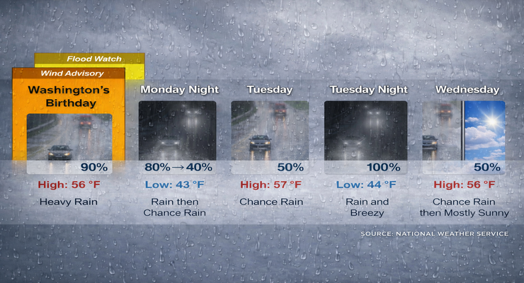
Here is the Pasadena forecast from the National Weather Service as of 3:14 a.m. Monday:
President’s Day: Rain and possibly a thunderstorm. Some of the storms could produce heavy rainfall. High near 56. Southeast wind 10 to 15 mph becoming southwest in the afternoon. Winds could gust as high as 20 mph. Chance of precipitation is 90%. New rainfall amounts between 1 and 2 inches possible.
Monday Night: Rain and possibly a thunderstorm before 10:00 p.m. then a chance of rain. Low around 43. West southwest wind 5 to 10 mph. Chance of precipitation is 80%. New precipitation amounts between a quarter and half of an inch possible.
Tuesday: A 50 percent chance of rain. Mostly cloudy, with a high near 57. South southwest wind around 15 mph, with gusts as high as 20 mph. New precipitation amounts between a tenth and quarter of an inch possible.
Tuesday Night: Rain, mainly before 4:00 a.m. Low around 44. Breezy, with a west southwest wind 15 to 20 mph, with gusts as high as 30 mph. Chance of precipitation is 100%. New precipitation amounts between three quarters and one inch possible.
Wednesday: A 50 percent chance of rain before 10:00 a.m. Mostly sunny, with a high near 56.
Wednesday Night: A 30 percent chance of rain, mainly after 4:00 a.m. Partly cloudy, with a low around 40.
Thursday: Rain likely, mainly after 10:00 a.m. Partly sunny, with a high near 53.
Thursday Night: A chance of rain. Mostly cloudy, with a low around 39.
Friday: A slight chance of rain. Mostly sunny, with a high near 61.
Friday Night: Partly cloudy, with a low around 41.
Saturday: Sunny, with a high near 65.
Saturday Night: Partly cloudy, with a low around 45.
Sunday: Mostly sunny, with a high near 70.
Altadena Calendar of Events
For Pasadena Events, click here