
Altadena Now is published daily and will host archives of Timothy Rutt's Altadena blog and his later Altadena Point sites.
Altadena Now encourages solicitation of events information, news items, announcements, photographs and videos.
Please email to: Editor@Altadena-Now.com
- James Macpherson, Editor
- Candice Merrill, Events
- Megan Hole, Lifestyles
- David Alvarado, Advertising


Sunday, February 15, 2026
Flood Watch, Evacuation Warnings in Effect as Major Storm Targets Pasadena, Altadena Monday
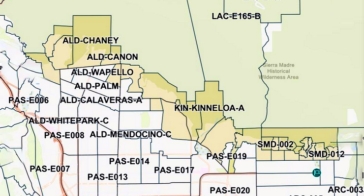
The Los Angeles County Sheriff’s Dept. has issued Evacuation Warnings for the Eaton Fire burn scar area starting Sunday, February 15 at 9 p.m., as shown above in areas shaded tan. [protect.genasys.com/zones]
National Weather Service warns of heavy rain, thunderstorms and debris flows on Eaton Fire burn scars; county orders residents near burn areas to prepare to possibly evacuate Sunday night
A powerful storm system bearing down on the San Gabriel Valley prompted the National Weather Service to issue a flood watch for Pasadena, Altadena and much of Los Angeles County on Monday, while county officials activated evacuation warnings for properties near the Eaton Fire burn scar beginning Sunday night at 9 p.m.
The storm, which the NWS described as “very significant and dangerous,” is forecast to deliver one to three inches of rain across the Los Angeles Basin and two to five inches in the foothills and mountains by late Monday — with the most intense rainfall expected between 6 a.m. and 6 p.m., according to the NWS.
For Pasadena and Altadena residents still recovering from the Eaton Fire, the primary danger is the threat of mud and debris flows on the unstable burn scar terrain.
Los Angeles County announced the evacuation warnings at noon on Saturday, February 14, according to the County’s emergency website. The warnings are valid from 9 p.m. Sunday, February 15, through 9 a.m. Tuesday, February 17, and apply to select parcels near recent burn areas.
Public safety personnel were notifying affected residents via door knocks, hang tags, Wireless Emergency Alerts and the Genasys Protect platform, according to the County.
Residents can check their evacuation status at protect.genasys.com.

The flood watch, issued by the NWS Los Angeles/Oxnard office at 12:20 p.m. Saturday, covers Monday, February 16, from 9 a.m. to 9 p.m., according to the NWS. The agency warned that “flooding caused by excessive rainfall is possible” and that “rock and mud slides are possible near steep terrain” and “debris flows are possible on burn scars.”
“Look out for neighbors and their property — especially those who may be away for the holiday weekend,” advised Pasadena Chief Communications Officer Lisa Derderian. “The good out of a bad storm is Monday is a holiday, so less vehicles likely on the road commuting, although many will be heading home from long road trips. Our burn scar area continues to be a priority for extra eyes due to the potential for flooding, mud and debris flow, and our same list of [at-risk] homeowners have been contacted regarding evacuation warnings.”
A high wind watch is also in effect for Monday from 6 a.m. to 6 p.m., with southwest winds of 20 to 30 mph and gusts up to 60 to 70 mph possible, the NWS said. The agency warned that damaging winds could blow down trees and power lines and that travel could be difficult, especially for high-profile vehicles.
In its Area Forecast Discussion, the NWS described the storm system as fueled by abundant moisture with precipitable water values near one inch, jet-stream winds reaching 150 mph at upper levels, and strong low-level forcing.
Forecasters said the storm’s front will move through the region from morning to early evening Monday and is expected to be “very convective,” with the potential for waterspouts to move onshore and weak, brief tornadoes to develop inland, particularly across the LA Basin, according to the NWS forecast discussion.
Monday’s storm is the first in a series expected to affect the region through at least Thursday, according to the NWS.
A second storm system is forecast to arrive Tuesday night into Wednesday, bringing colder temperatures and additional rain. An additional 1.5 to three inches is possible Tuesday and Wednesday, with a total of three to six inches of rain possible in the mountains, NBC Los Angeles reported, citing City News Service.
Snow levels are forecast to drop from around 6,500 feet early in the storm to near 5,000 feet by Tuesday, according to the NWS.
The Eaton Fire burn scar, which stretches across more than 14,000 acres in the San Gabriel foothills above Pasadena and Altadena, remains highly susceptible to debris flows more than a year after the fire. Even moderate rainfall rates exceeding a half-inch per hour can trigger dangerous mud and debris flows on the stripped terrain, LA County Public Works has said in previous storm advisories.
The NWS warned that flash flooding is possible and that excessive runoff may inundate low-lying and flood-prone areas, including creeks, streams and urban areas with poor drainage.
“Low-water crossings may be flooded. Extensive street flooding is possible,” the agency said. Residents in flood-prone areas should “be prepared to take action should flooding develop,” and travel through passes and canyons “could become dangerous,” according to the NWS.
Free sandbags are available to Pasadena residents at Fire Station 37, 3430 E. Foothill Blvd., and Fire Station 38, 1150 Linda Vista Ave., from 8 a.m. to 5 p.m., with a limit of 10 sandbags per resident with proof of residency, according to the city. Contractors are not permitted to pick up sandbags.
Elsewhere in the Eaton Fire area, a full list of County sandbag locations is available at lacounty.pw/sandbags.
What Residents Should Do
Officials are urging residents to take several immediate steps: secure outdoor furniture and loose items, stock food, water, flashlights, batteries and backup phone chargers, fully charge medical devices, bring pets indoors, clear debris from gutters, downspouts and storm drains, and prepare an emergency “go bag” with essentials including medications and important documents, according to the city and County guidance.
Residents in or near the burn scar are advised to be ready to evacuate immediately if an evacuation order is issued. An evacuation warning means residents should prepare for possible evacuation; an evacuation order means residents must leave immediately due to an imminent threat to life, according to Cal Fire definitions.
The city also warned residents to treat all downed power lines as live and dangerous, avoid driving through flooded roads — “Turn Around, Don’t Drown” — and stay away from flood control channels, canyons and natural waterways. For power emergencies, residents can call (626) 744-4138, according to the city.
Emergency Alerts and Resources
Residents are encouraged to register for the Pasadena Local Emergency Alert System (PLEAS) for voice, email and text emergency notifications.
The County’s Alert LA County system is available at lacounty.gov/emergency, and the Genasys Protect platform at protect.genasys.com provides address-specific evacuation zone information. Nixle, the Pasadena Police Department’s primary notification system, is available at Nixle.com or by texting a ZIP code to 888777, according to the city.
For life-threatening emergencies including flooding trapping residents or debris flows threatening homes, residents should call 911. Non-emergency issues such as fallen trees or localized flooding can be reported through the city’s 3-1-1 system. The County’s storm damage report line is available 24 hours at 800-675-4357, according to LA County Public Works.
The NWS said Monday’s storm will be the strongest of the week, with rain expected to continue in diminishing intensity through at least Thursday. Forecasters advised residents to monitor later forecasts and be alert for possible flood warnings as conditions develop.
Altadena Calendar of Events
For Pasadena Events, click here