Altadena Now is published daily and will host archives of Timothy Rutt's Altadena blog and his later Altadena Point sites.
Altadena Now encourages solicitation of events information, news items, announcements, photographs and videos.
Please email to: Editor@Altadena-Now.com
- James Macpherson, Editor
- Candice Merrill, Events
- Megan Hole, Lifestyles
- David Alvarado, Advertising



Monday, July 13, 2026
Brace for Triple-Digit Heat, Midweek Humidity
NATIONAL WEATHER SERVICE
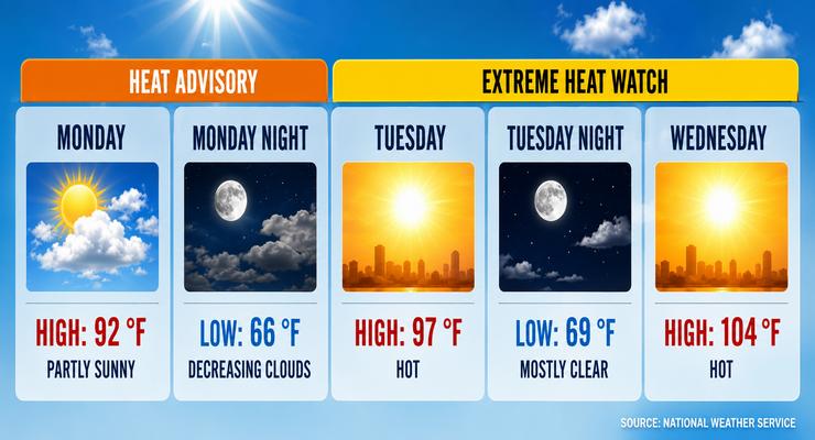
A dangerous heat wave will grip Pasadena beginning Tuesday, with temperatures climbing into the triple digits and humidity adding to the discomfort, forecasters said.
The National Weather Service in Los Angeles/Oxnard reported late Sunday that highs will rise each day through midweek, peaking Wednesday at 104 degrees. Officials warned of widespread Moderate to Major HeatRisk from Tuesday through Thursday.
On Sunday, Pasadena reached 92 degrees under partly sunny skies. Winds were light, shifting southwest at 5 mph. Overnight lows fell to 66 degrees.
Monday will bring highs near 97 degrees with light winds. Tuesday will be hotter, reaching 97 degrees, before Wednesday’s peak of 104 degrees. Lows will remain in the upper 60s to low 70s, offering little relief.
Forecasters said monsoonal moisture could trigger isolated showers or thunderstorms in nearby mountains Monday and Tuesday afternoons. Pasadena itself is expected to stay dry but muggy.
Winds will remain calm to light, generally from the southwest at 5 to 10 mp.
By Thursday, highs will ease slightly to 99 degrees. Friday through Sunday will bring a cooldown, with highs near 89 degrees and partly sunny skies. Nights will be mild, with lows in the mid-60s.
Forecasters cautioned that Pasadena’s urban heat island effect will worsen conditions, especially in densely built neighborhoods. Residents are urged to limit outdoor activity, stay hydrated, and check on vulnerable neighbors.
Extreme Heat Warnings are expected Tuesday through Thursday. The National Weather Service recommends completing outdoor tasks early in the day and avoiding strenuous activity during peak afternoon hours.
Looking ahead, temperatures are expected to remain near seasonal averages next week, though humidity may stay elevated due to lingering tropical moisture.
Here is the Pasadena forecast from the National Weather Service as of 10:32 p.m. Sunday:
Today: Partly sunny, with a high near 92. Calm wind becoming southwest around 5 mph in the afternoon.
Tonight: Mostly cloudy, then gradually becoming mostly clear, with a low around 66. Southwest wind around 5 mph becoming calm in the evening.
Tuesday: Sunny and hot, with a high near 97. Light and variable wind becoming west southwest 5 to 10 mph in the morning.
Tuesday Night: Mostly clear, with a low around 69. Southwest wind around 5 mph becoming calm in the evening.
Wednesday: Sunny and hot, with a high near 104. Calm wind becoming southwest around 5 mph in the afternoon.
Wednesday Night: Mostly clear, with a low around 72.
Thursday: Sunny and hot, with a high near 99.
Thursday Night: Mostly clear, with a low around 65.
Friday: Mostly sunny, with a high near 89.
Friday Night: Partly cloudy, with a low around 64.
Saturday: Mostly sunny, with a high near 89.
Saturday Night: Partly cloudy, with a low around 64.
Sunday: Mostly sunny, with a high near 89.
Altadena Calendar of Events
For Pasadena Events, click here